
Salisbury Previous Residents by Era
A backward address trail changes sources as it crosses eras. The Rowan Register of Deeds supplies the recorded land chain; the Rowan Tax Assessor real-property search and GIS help connect an address to a parcel; city directories and Sanborn maps provide dated household or building context; and the History Room and NC Archives hold local material that does not live in a current parcel system. Start with the source nearest the date in question, then use a second source to test what it means. A property owner, directory listing, court party, and newspaper subject are distinct record roles.
| Source | Years It Covers | Where Held | What It Shows |
|---|---|---|---|
| Rowan Register land index | Pre-1975 land begins 4/12/1753; separate current endpoints cover later land records | Register of Deeds and online land-record system | Filed documents, grantor, grantee, book/page, description, and images where available |
| Tax Assessor parcel and ownership history | Tax-year views; no universal historical range stated | Rowan real-property search and parcel profile | Parcel identity, property and mailing fields, legal description, and transaction references |
| Salisbury city directories | Reported issues from 1901 through 1950, with gaps | History Room, historic surveys, and DigitalNC for 1919-20 | Dated household, street, and business leads |
| Salisbury Sanborn maps | 1896 LOC set; additional years cited in local collections | Library of Congress, History Room, and NC Archives microfilm | Building footprint, use, and block context |
| Archives wills and court material | Wills indexed 1743-1971; court minutes from 1755 | NC Archives and Salisbury District finding aid | Estate, heir, guardian, court, and historic residence clues |
For a recent recorded transfer, begin with the Register. For a turn-of-the-century occupant question, start with a directory and map, then use the land chain and newspaper or Archives record to check the lead. No row in the table proves that a named person occupied the property.
Salisbury Deed Record Dates
Before following a deed backward, save the Register's coverage statement with the access date. The certified-date page inspected on August 29, 2026 showed land records for 1975-1994 current from January 1, 1975; consolidated real property current from January 3, 1995; and pre-1975 land current from April 12, 1753. It also showed each current endpoint certified through August 27, 2026. These are coverage labels, not a guarantee that every index entry or image is complete, and they can change as the portal is updated.
The Rowan Register certified-dates page is the source for this Salisbury deed-coverage image.
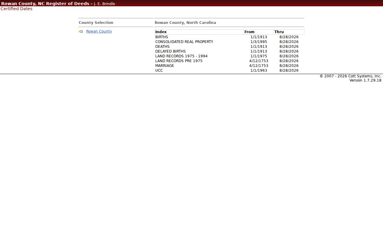
The 4/12/1753 starting point is a useful historical marker because it matches Rowan County's formation year. Record the label and the certified-through date before relying on a search result, especially when a portal has recently shown maintenance or unavailable messaging.
Note: Coverage metadata states what the custodian reports online, while a deed image and the counter record remain the documents to inspect for a particular transaction.
Trace Salisbury Deed Records
The deed chain follows the parcel more reliably than a street name. The Rowan Assessor card provides the parcel ID, situs address, tax mailing address, legal description, and recorded transaction references. The Register index then offers date filed, document kind, grantor, grantee, description, book/page, reference, amount, and image controls. Its description field is labeled “Not Warranted,” so the index is a lead rather than the controlling text. The online system has an account/login boundary and identifies historical images for 1753-1875, Record Books 1-50. Pull the recorded deed and any referenced plat before matching older documents to the property.
- Search the Assessor by one field, such as parcel ID, address number and street, owner name, book, or page. Retain the parcel ID, situs address, mailing address, and legal description separately.
- Use the current book/page or transaction reference to find the recorded instrument in the Register index. Save the filed date, document kind, grantor, grantee, and any prior-instrument citation.
- Read the deed image and its legal description. A grantor is the party transferring an interest; a grantee is the party receiving it.
- Find the deed that put title into the prior grantor, using the legal description, earlier book/page, plat reference, and name indexes rather than a street search alone.
- Repeat backward, noting deeds, easements, rights-of-way, and parcel changes that can break a simple address trail. Use the Register counter for archived books, images, or staff direction when the online route ends.
- Chain of title
- The sequence of recorded instruments that passes an interest in the same parcel from one party to another.
- Legal description
- The lot, block, subdivision, township, metes, or other parcel wording in a record. It is more durable than a street label when addresses change.
- Book/page
- The recorded-volume citation used to locate the instrument and its prior references.
Salisbury Address Record Trail
Keep three possible address strings in the working record: the historical directory address, the current property or situs address, and the owner mailing address. Rowan's parcel examples show why. A property can have a mailing address that serves tax notices or another function, and a city mailing label does not prove municipal limits. The Assessor separates property characteristics and ownership history from recorded deed custody, while GIS adds the city-limit, county-boundary, neighborhood, and street context.
For a difficult match, search an exact legal-description fragment as well as the street name. The research sample included township, block, lot, and subdivision language such as L3 4 MELROSE HGTS BLK B SAL TWP. That kind of wording can bridge a numbered street, a subdivision plat, and an older deed even when the address has shifted. It still must be checked against the recorded image and plat.
Salisbury Address Maps and Records
For the household layer, combine a dated directory with a dated map before moving back to the deed chain. The 1919-20 digitized Salisbury-Spencer directory, the History Room's local collections, and the Library of Congress 1896 Sanborn set provide different types of evidence. DigitalNC attributes the 1919-20 item to Ernest H. Miller and Piedmont Directory Co., while a National Register survey names Commercial Service Co.; inspect the title page before stating a publisher. Sanborn sheets show physical structures and surrounding use, not the person who lived there. A footprint match is not proof that the same household occupied a building.
- Record the directory's printed year, publisher, page, name, and address form.
- Locate the relevant Sanborn sheet or other dated map and note the building footprint, block context, and map year.
- Compare the historical street wording with the current GIS address point and road centerline without silently changing the old form.
- Use the parcel legal description and tax-card transaction references as a bridge to the Register book/page.
- Pair directory years with the appropriate census years, then seek a newspaper, probate, will, or court record that independently supports a move, estate role, or household link.
The publisher runs, title-page issue, and entry-reading rules are detailed in the Salisbury Directory Book. Here, a directory is one dated step in the address trail, not a replacement for the collection itself.
Salisbury Address Records at Archives
The NC Archives county-records box lists lead to historical Rowan marriage, estate, divorce, and related holdings. Archives material adds routes that a parcel page cannot supply: marriage bonds before 1868, licenses after 1868, cohabitation bonds for 1866-67, guardianship, inheritance tax, divorce records since 1835, historic court minutes and dockets, and private collections. The Rowan County wills resource describes an index across 111 fibredex boxes for 1743-1971.
The NC Archives Rowan County records finder is the source for this Salisbury Archives image.
Use the Archives copy-request form when a specific record type is known. It asks for a person, year, county, and pertinent information. In-state searches have no upfront search fee, copies cost $2 up to 20 pages plus $0.10 per additional page, and out-of-state requests require $20 upfront. The Archives in Raleigh and the Rowan History Room are also in-person routes when an online index is incomplete.
Salisbury Address Records in News
Newspapers can establish a date or address association that a deed cannot explain. The NC Archives guide lists partial Salisbury and Rowan runs, including Evening World from 1895-1898, Salisbury Daily Index from 1899-1900, Salisbury Daily Sun from 1897-1904, Salisbury Examiner from 1881-85, and older Banner titles. Search the period closest to the directory or deed, then preserve the newspaper title, issue date, and page. The guide is a finding aid, not a guarantee that every issue is online or extant.
Court material can also be a lead, but it belongs with the proper custodian. The Salisbury District Superior Courts finding aid identifies minutes from 1755 onward and various dockets. A court role can be an executor, witness, guardian, grantor, grantee, or another limited role, so it does not itself establish occupancy. For current records, the Rowan courthouse clerk and public terminal remain the local inspection and copy route; for older files, use the Archives finding aid and box lists.
Salisbury Address Record Limits
Past-resident research is best kept to house history, family history, estate questions, and other lawful personal research. North Carolina's Public Records Act concerns existing public records, and a custodian may redact protected fields or decline to create a new list. Certified vital records have relationship and authorized-purpose rules. Court juvenile, sealed, expunged, and involuntary-hospitalization material is not ordinary public search material.
Address safety. If a record suggests North Carolina Address Confidentiality Program coverage or a protective-order-protected address, stop triangulation and use only the official program explanation or safe agency contact.
Owner is not the same as occupant, and an old directory listing is not a present-location claim. Keep the source, source date, jurisdiction, record role, and confidence beside each note. That restraint prevents a compelling house story from turning into an unsupported identity claim.
Salisbury Records Before 1836
Before 1836, “Rowan” does not automatically mean modern Salisbury or even present Rowan County. Rowan County formed in 1753 from Anson and once covered a much larger territory; the county plan says its current boundaries stabilized by 1836. Check historical county geography before assigning a deed, will, court minute, marriage bond, or newspaper item to a Salisbury address. Retain the original place label and the record year even when later sources use a different name.
This caution matters most at the far end of a deed or will trail. A deed index beginning in 1753 is valuable, but historical geography, legal descriptions, and custody records must be reconciled before a modern parcel is connected to an eighteenth-century reference.
Salisbury Address Map Records
County and city GIS are discovery tools for the trail, not legal proof. Rowan GIS publishes parcel lines, address points, roads, subdivisions, zoning, and historic-landmark layers. Salisbury's service lists address points, parcels, neighborhoods, historic districts, city limits, non-annexation boundaries, and the county boundary. Use those layers to compare a historical address with current geography and to see whether a parcel is inside the city, then verify the result against the deed and plat.
The city warns that its maps are approximate and should be checked against deeds and plats. A public parcel line is not a survey, and a postal Salisbury label does not settle municipal jurisdiction. This geographic check is a useful stop before joining an old directory address to a modern property record.